Project Overview
The Association for Infrastructure Geospatial Information Distribution (AIGID, Representative Director: Yoshihide Sekimoto) works to strengthen the geospatial information industry in Japan and to foster new businesses and services. By bringing together organizations from industry, government, and academia, we are developing an environment that supports the collection, distribution, and use of information related to social infrastructure.
We also run the Urban Data Challenge (http://urbandata-challenge.jp/ ), which helps local governments make better use of their data to address regional challenges. This initiative supports the discovery of administrative data, new ideas for data use, and the creation of applications and solutions.
- Representative director
- Yoshihide Sekimoto
- Established
- September 2011
- Purpose of Establishment
- It is a Public/Private/Academic consortium established with the aim of improving the environment for collecting, distribution and efficient use of social infrastructural information including geospatial data.
【See Reference Material 4 (ja)】
- Contact
- Jota Yamamoto(Secretary-General)
- office(at)aigid.jp ※ Please replace (at) with @ when sending an email.
- Tel
- +81-3-6455-1845
- ※1 Geospatial Information
- It is synonymous with geospatial information and refers to information that indicates the location of a specific point or area on the Earth's surface (including temporal information associated with that data), or to positional information and information associated with that position.
- ※2 Urban Data Challenge
- As a concrete initiative to promote the publication and distribution of data held by local governments and other institutions, this program involves organizing the datasets that each organization can provide, and soliciting effective tools and methods for utilizing those datasets. Since 2013, the initiative has been implemented across an expanding number of regional sites, reaching a total of 49 locations by the end of fiscal year 2018.
Here is an introduction to each of the project sites.
Geospatial Information Center
Geospatial Information Center
For a Data Powered Community
Centralized Platform Supporting the Utilization and Distribution of Geospatial Information
Go to the Geospatial Information Center website
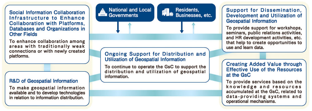
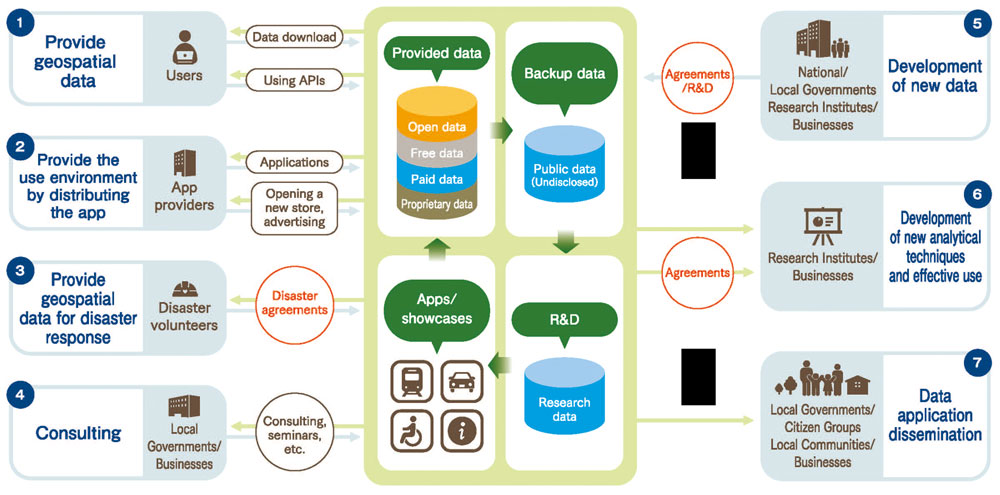
The Geospatial Information Center (GsC) is a platform that promotes the effective use and distribution of specialized Geospatial information generated and maintained by various groups for diverse purposes. It also provides logistical support to actors working to solve social issues. The center was established based on the "Basic Plan for the Advancement of Utilizing Geospatial Information" approved by Cabinet members of the Japanese government in March 2012, and has been in operation since November 24, 2016. The GsC is managed by the Association for Promotion of Infrastructure Geospatial Information Distribution (AIGID).
It provides a one-stop search system for geospatial data and related information which users require, whether for a sales purpose or free of charge. In general, the center is a platform that supports distribution of data that maximize the social value of geospatial information. Our activities include participating in various events, promotional activities, and organizing seminars. In addition, we deploy projects aimed at innovation creation, such as R&D and data curation.
Data Handled and Organizations Registered
The platform is supplied with a large number of data sets and files from various organizations.
Registered
As of Aug. 2025
Collaboration Across Organizations
The GsC promotes the effective use of geospatial information by integrating and combining information among public, private and academic sectors, contributing to the creation of high value for society as a whole.
Our Services
We provide one-stop access to a variety of geospatial information (G-spatial information).
Urban Data Challenge(UDC)
Urban Data Challenge(UDC)
Resolving Local Public Issues Based on Public Data
Go to the Urban Data Challenge website
This is an initiative to promote the effective use of public data from local governments with the aim of resolving local public issues.
Launched in 2013 by the Association for Promotion of Infrastructure Geospatial Information Distribution (AIGID), the challenge consists of two elements: data-driven community building and product contests open to the public.
In terms of data-driven community building, “regional hubs” were designated in each prefecture over the five years from 2014 through 2018 in which the use and distribution of geospatial information are promoted.
In terms of product contests, activities have continuously centered on awarding outstanding products that contribute to solving regional problems, submitted through public calls for entries each year.
Holding Contests
Every year, we hold a contest for the most effective tool, idea, data set, etc. to solve local public issues by making active use of open data. The number of entries has been increasing year after year.
Local Base Points throughout Japan
From FY2014 through FY2018, participants representing the “local base points” of prefectures across Japan engaged in the challenge aimed at forming a data utilization community, which is the core of our activity, achieving a total of 132 events held throughout the local base points and with approximately 3,200 participants (recorded in FY2018). Coordinators in the local base points take the lead in organizing various events throughout Japan, such as ideathons, hackathons and walk around events, to identify local issues, generate ideas to solve problems, and develop tools.
My City Construction
My City Construction
Online Electronic Delivery System
Electronic Results of Road Work, Construction, etc. Can Be Delivered Online!
Go to the My City Construction website
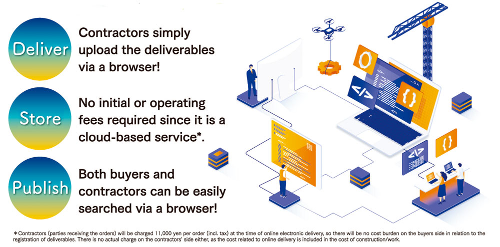
What Is the Online Electronic Delivery System (My City Construction)?
With the recent full-scale launch of “i-Construction” by the Ministry of Land, Infrastructure, Transport and Tourism, the collection of 3D data, such as point cloud data, is increasing at public construction sites managed by local governments, etc. However, not much good use of the electronic deliverables containing such data have not been made so far. In this context, to support efficient delivery and enhanced utilization of the deliverables, we built and launched an online electronic delivery system called “My City Construction” (MCC), which has been in full operation since FY2020. As a cloud-based service, MCC does not require any initial or maintenance fees*, making for easy adoption not only by prefectural governments but also by smaller municipalities.
MY CITY FORECAST
MY CITY FORECAST
Go to the My City Forecast website
Urban planning can no longer continue “as it always has.”
Have you ever imagined how your own community might change in the years to come?
In the near future, Japan is expected to face an unprecedented era of population decline. Cities will inevitably transform in response, and it is essential that urban planning incorporates evaluations from the citizens’ perspective at the planning stage to create effective strategies.
To achieve this, it is important to understand how your community may evolve in the near future.
"My City Forecast" visualizes the expected living environment from 2015 to 2040 based on current data such as population distribution and facility locations. Through simple simulations, it illustrates—across 14 indicators—how everyday life and the urban environment could change if the projected city structure were to become a reality.
When deciding where to live, what aspects of a community make it attractive to you? What kind of town would you like to live in in the future? This tool is designed to spark those reflections and help citizens think about their own answers.
My City Report
My City Report
Citizens’ Participation Makes the City a Better Place to Live
Go to the My City Report website
“My City Report” is the collective name for “My City Report for Citizens,” which enables citizens and local governments to collaborate to address community issues, and “My City Report for Road Managers,” which detects road damage accurately and quickly using a smartphone mounted on a vehicle. It is operated by the My City Report Consortium, which is comprised of user municipalities.
My City Report for Citizens
“Citizens' Collaborative Posting Service” for Posting ‘Problems’ Around the Community
Citizens can share local issues with the local government and other users by posting “problems” they find in the community. The local government, on the other hand, can centrally manage reports collected via phone, email, LINE, etc. and patrol results on the control screen.
My City Report for Road Managers
AI-powered Detection “Road Damage Detection Service”
AI (Artificial Intelligence) will replace traditional visual inspections of road damage that has been conducted by many municipalities, which will improve operational efficiency through accurate and quick detection of road damage.